
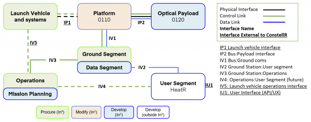
 Platform
  Payload
  Ground Stations & Mission Management
  Ground Networks & Data Distributions
  Data Processing & Visualisation
  Data Analytics, Insights & Applications
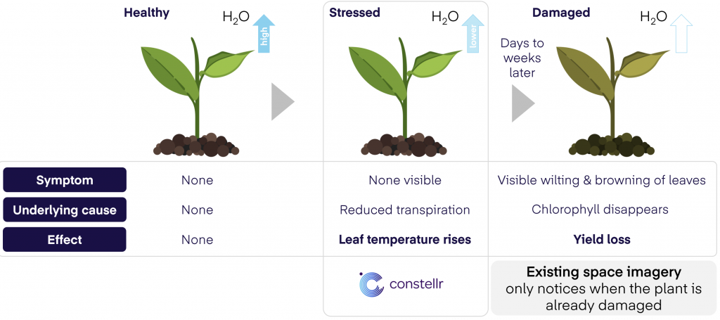
 constellr’s data provides a true temperature measurement of Earth’s surface, on a daily basis, at sub-field level, globally. This land surface temperature (LST) dataset has as its main goal to disrupt Smart Farming, currently reliant on physiology-based vegetation indices, derived from standard optical or near infrared satellite imagery, to determine crop health. Such indices infer crop stress from visual signs such as change in leaf colour, usually detected only after irreversible crop damage has occurred.
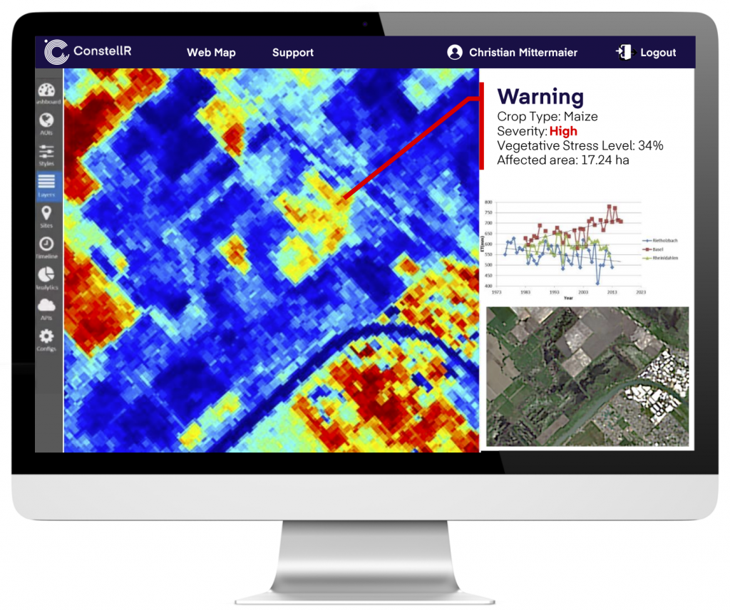
constellr’s products aim to give an immediate measurement of crop health, as plants become stressed, by identifying plant transpiration changes from leaf temperature. Critically, this provides days or weeks advance warning so that remedial action can be taken by farmers earlier and before irreversible damage occurs, resulting in far lower risk of crop loss, more efficient use of scarce resources, and improved yield forecasting capability. Our products provide reliable information for such yield predictions, impartial data for policy development and high-quality insights to help reduce uncertainty in the production and logistics supply chain. A state-of-the-art data delivery mechanism, using global ‘ground station-as-a-service’ infrastructure and hyper-scalable cloud capacity aims to ensure minimum latency between satellite measurement and receipt of crop stress information.
The key customer segments targeted by our product are split as follows:
1 – Large agtech and agribusiness companies who develop digital smart farming solutions for their own customers or who are prolific traders who need to optimise their supply chain and production activities. These customer require reliable information for crop yield forecasts and data which helps reduce uncertainty in the production chain. At present, they are forced to trade off between high planning uncertainty (EO products), high effort / cost (in situ products) and timeliness (3rd party reports).
2 – EO data analytics companies who apply ML/AI etc. to big data models and develop their own products and services for agricultural customers. They must offer cost-efficient, quality products to help maintain and grow a competitive position in market. Current data does not allow them to create sufficient additional value to pass entry barrier for customers.
3 – National research entities & regulatory bodies undertaking sectoral research or developing agricultural policy. High requirement for impartial data to quantify the status quo and monitor and understand trends influencing progress towards policy goals. The quality of current datasets and lack of or inconsistent monitoring capacity is a major challenge for these customers.
Pan-Europe: smart farming stakeholders for whom data and farm management information systems are the norm (Germany, Netherlands, France, Spain, Turkey etc.) Beyond Europe, the key global agricultural production areas including but not limited to: USA, South America, Middle East (Israel), Asia (Turkey) and eventually Sub-Saharan Africa.
constellr’s 50m land surface temperature data gives an immediate measure of crop health, as the plant becomes stressed, by identifying plant transpiration changes from leaf temperature. In contrast to current methods, which react to visible signs such as colour change and wilting, constellr’s insights provide advance warning of stress so that remedial action can be taken by farmers earlier and before irreversible damage occurs. This results in far lower risk of crop loss, more efficient use of resources, and improved yield forecasting capability.
constellr’s customers can subscribe to data for their AOI, with cost being a function of area size, revisit frequency, and timeliness (latency). Recorded data in the thermal infrared and VNIR spectral regions are downlinked, processed to Level-2 Land-Surface Temperature, and then delivered via API to the ordering customer.
constellr’s TIR payload uses proprietary design elements in cryocooling sensors, high performance thermal systems and optics to miniaturise traditional TIR sensor payloads to the size of more agile microsatellites. Novel operational concepts such as “virtual calibration” (VCAL), reduces space segment costs massively. Our data distribution platform further leverages the cost benefits of hyperscalable cloud technology to distribute our critical data to a global customer base.
Currently, there are four main measurement approaches on the market: In-situ monitoring of irrigation systems (which do not provide the complete picture of plant water consumption); In-field indirect measurement of temperature (good results but expensive, non-scalable and complicated modeling); Aerial remote sensing of temperature via drone or UAV (high spatial resolution but prohibitively expensive at scale). Remote sensing via satellite (consistent, scalable monitoring, but a compromise between lower resolution, or revisiting the same spot less often; complex image processing and extremely high capex investment. The costs are spread over a much larger user group however and are therefore lower than drones).
Currently, no satellite system exists to produce precise TIR measurements at high spatio-temporal resolution. We offer a cloud-based data platform providing crop water stress information for stakeholders in the agricultural sector. That’s water need for every field on the globe, every single day. It is globally scalable: a single system to cover the whole planet. It is affordable for use in developing countries. It is reliable as it is based on precise physical measurements and proven analytical methods. And it is timely: detecting crop water stress before damage occurs to enable earlier and more effective mitigation.
The activity kicked-off in November 2022.

